GIS mapping: every valve, hydrant, and main on a map that stays current.

Utility mapping software for small water and wastewater utilities
Most small utilities are not missing a map. They have one. The problem is what is behind it, which is nothing.
A living map fixes that. No per-seat fee, so the whole crew carries it. Here is how it works and where it fits for a system your size.
- A roll of paper or a PDF an engineer handed over
- Dots and lines with no record attached
- Getting wronger every day since it was drawn
- Each tap opens the real record: who installed it, size and material
- Every repair and inspection, right there
- Gets more accurate the more your crew works
What does GIS mapping software actually do for a water utility?
It turns your system into a live map your crew builds and keeps current from the field.
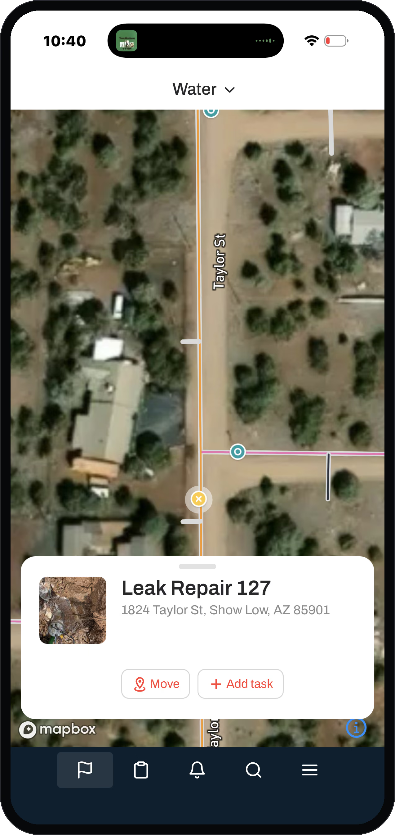
Every point and line is something you can tap: a hydrant, an isolation valve, a water main, a meter, a lift station. Tap one and you get its record: when it went in, what it is made of, everything anyone has ever done to it, and who touched it last.
The difference from a plain map is that the work rides on the map. When your operator exercises a valve, he does it on that valve, and what he logs lands in the record right there. The map is not a reference picture off to the side. It is what the whole crew works through every day.
That covers the assets a small water or wastewater system actually runs:
New to GIS entirely? Start with What is GIS?, the plain-English explainer written for operators.
Distribution
water mains, service lines, curb stops, meters, isolation valves, control valves (PRVs), fire hydrants
Sources and storage
wells, well pumps, booster stations, storage tanks
Wastewater
gravity mains, force mains, manholes, cleanouts, lift stations, grinder pumps
Why is a dead map worse than no map?
Because the second you stop trusting it, you stop using it.
A paper map or a one-time drone flight is a snapshot that is wrong by the time it is drawn. New lines go in and the old ones never get capped, so they sit there active and undocumented. A manhole gets asphalted over and the field truth vanishes between visits.
A living map gets better instead of worse, and the way it does it is the part nobody else builds. Map data you inherit (an old shapefile, a paper drawing, the retiring operator's memory) comes in gray. Gray means nobody has put eyes on it yet, which tells the crew exactly what to go verify. When somebody is out there anyway, they confirm the gray valve is really where the old map said. They drop a photo, fix the depth, and it stops being gray. Over a year or two, the locates and repairs your crew already does turn your old paper into a map you trust.
Does my whole crew get the map, or just the office?
The whole crew. Pricing is by service connections, not per seat.
Every operator and field tech can have the map on a phone instead of one login on the office computer. That is the opposite of how most GIS is priced, on purpose.
The people who most need an accurate map are the field crew, so they get the power to build and update it. That makes a loop: the crew benefits from good data, so the crew puts good data in. You end up with a map that is actually current. Open access cuts both ways, so it is paired with role restrictions and a full history log. Every change is recorded with who made it, so if someone fat-fingers an edit you recover it and see who did it. The openness keeps the map alive. The log keeps it safe.
Bad coverage does not stop them either. The job still logs on the phone and syncs when the truck gets bars back.
Do I need a GIS background, or is this different from ESRI?
You run it yourself, with the crew you already have. Think ArcGIS, Field Maps, and Survey123 without the parts a small utility never touches. It will not track bird migrations. It will help you find your main without so much hand digging.
You are not configuring a blank, generic mapping tool: the water and wastewater thinking is already built in.
We have seen a 350-connection system pay roughly double its subscription price just in consulting, support, and engineer fees. And we have seen a small system quoted $28,000 for a map the operator could not update or edit, with no work orders attached. That is gatekeeping. A living map you own is the opposite of that.
- Built for engineers doing design work and hydraulic modeling
- Small utilities use only the dots-on-a-map sliver
- The cost is the consulting and engineer time bolted on
- ArcGIS, Field Maps, and Survey123, without the parts you never touch
- Water and wastewater templates already built out, works out of the box
- Built for the daily work an operator and field crew live in
Is the map the whole thing, or is there more?
The map is where it starts. Everything else sits on it.
Once your assets are on it, work orders attach to each asset and the cost of each job (parts, equipment, labor) rolls up onto it. The 811 locates you are already required to do auto-create assets your crew can photograph and verify. That last one is how digitizing your old paper becomes a process instead of a project. GIS packaged with work management is a genuinely different thing than a map by itself.
How do I get started if all I have is paper?
You start with what you have.
Paper maps, an old shapefile, a billing spreadsheet of meters, whatever exists. We import it and drop the assets at approximate spots, then your crew refines them in place as they work. A small system can have its dots on the map in a couple of hours. Nobody starts with clean data in this line of work, and you do not have to. The point is to start now and get better as you go, not to wait until everything is perfect.
Work assigned straight from the office to the crew in the field, instead of chased down over the radio.
Mogollon Water Management, a northeast Arizona water utility, after getting its systems on the map.
Questions operators ask
What is the best cloud GIS for a utility company with field crews on tablets?
The one your crew will actually keep current from the field. For a small water or wastewater system, that means a map-first app with full access on any phone or tablet and no per-seat fee. The crew that benefits from the map is the crew building it, which keeps it accurate.
What is a dead map?
A map that is only right for the day it was made. Dots and lines with nothing behind them, like a paper map or a one-time drone flight. It goes stale as soon as the system changes, and once you stop trusting it you stop using it. A living map updates as a byproduct of the work and gets more accurate over time.
Gray means nobody has put eyes on it yet, which tells the crew exactly what to go verify.
Do small water systems even need GIS?
Yes, but not the enterprise kind. A small system needs to see where everything is, what shape it is in, and what it has cost, on a phone in the field.
The water and wastewater templates are pre-built and ready when you log in, and you can shape them to your system, with the crew you already have.
We already have ESRI, why would we switch?
You may not need to. If ESRI is working for you, keep it. We import your data and run alongside it. Most small utilities, though, pay for an engineer's tool and only use the map sliver. The real cost is the consulting and support around it, not the license. Ziptility is ArcGIS, Field Maps, and Survey123 without the parts you never touch, plus the work management ESRI does not do. (For a full side-by-side, see our ESRI comparison.)
For a map the operator could not update or edit, with no work orders attached.
Can I import my paper maps or shapefiles?
Yes. You start with what you have, including bulk shapefiles, CSV, and KML. We drop the assets in and your crew refines them in place as they work the system.
Keep reading
More on getting your system onto a map
Five pieces that go further than a product page can, written for the operator who is still working out whether any of this is worth the trouble.
From paper maps to digital GIS
Where to start when the system only exists on paper and in one person's memory.
Read the starter guidePaper maps, filing cabinets, and the Monday that changes everything
What the switch actually looks like at a system with no GIS specialist on staff.
Read what the switch looks likeThe map gets smarter every day. Or it doesn't
An engineering map updates during projects. An operations map updates every time your crew touches an asset.
Read the differenceWhy your utility needs more than a mapping app
A map shows you where the pipe is. It does not tell you who fixed it last, or what they found.
Read why a map is not enoughWho owns your map?
At most small systems the engineer holds the GIS and the crew just looks at it. That is backwards.
Read who should hold the dataPut your whole water system on one map your crew keeps current.
Start with what you have, paper maps, an old shapefile, whatever exists, and your crew refines it in place as they work the system.