What is mobile asset management when the assets are buried?
Mobile asset management puts the map and the history of every main, valve and hydrant on the crew's phone, and lets them update it where the work happens.
Blake Anderson
|
October 2, 2026
|
5 minutes to read
Key Takeaways
Mobile asset management means the map and records for your mains, valves, hydrants and meters ride with the crew on a phone or tablet.
At a utility the assets are buried and they stay put. The job is knowing what's down there, not tracking where equipment went.
What changes is who updates the record. When the person standing at the valve can fix the map, it stops going stale.
Start with the valves your crew can't find at night: a daylight photo, the distance from something fixed, and the turns to close.
Phone GPS is close enough to find most things; a receiver helps with boxes that got paved over.
The valve you need is three miles out on a county road. The record of where it is, how many turns it takes and who last exercised it sits in a binder at the office. Or in one person's head. Mobile asset management closes that gap. The map and the history for every main, valve, hydrant and meter go on the phone your crew already carries, and the crew updates that record where the work happens.
What mobile asset management means at a small utility
Mobile asset management is keeping the record of your system on a phone or tablet. The crew looks things up and changes them in the field, not at a desk. At a water or sewer utility the assets are the things in the ground: mains, service lines, valves, hydrants, meters, manholes, lift stations.
Search the phrase and most of what comes back is about something else. IT departments use it for company phones and laptops. Fleet managers use it for trucks and rental equipment. Those assets move, and the question is where they went.
Yours don't move. The question is what's down there, what shape it's in, and what was done to it last time.
Why the record has to ride in the truck
Most small systems keep their records in a paper map, a binder and somebody's memory. All of it stays behind when the crew drives out.
That holds up until the person who remembers is on vacation, or retires, or is the one standing in the ditch at 2 a.m. A superintendent in North Carolina put it plainly: "I have my system mostly memorized and so I can walk out there and stand right on top of the water main. And that's a problem."
At Mogollon Water Management, a water utility in Arizona, the crew is four people in the field and one in the office. What I care about is that when my guys get out there, they know this main is three feet deep. And that last time we were down this street, it was six feet off that fence post. On a break in the middle of the night, hunting for a valve nobody has touched in years, the photos are what I lean on most. A good one taken in daylight, lined up with the street, shows you where it is.
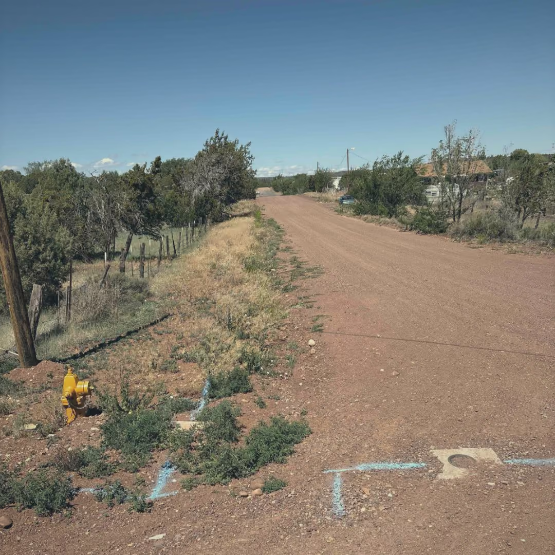
Blue locate paint in a dirt road, pointing at a valve box, with the hydrant and the fence line in the same frame.
The other half of the problem comes after the job. The crew fixes a leak or uncovers a curb stop that isn't on any map. If writing it down means a trip back to the office, a lot of it never gets written down. Next year somebody digs in the wrong spot again.
What changes when the crew can update the record
Paper records age badly. A superintendent in Kansas described the notes that came with the job: "It's like 'it's over here by this tree stump.' Well, the tree's been gone for 10 years, buddy."
When the person standing at the valve can update the record, it stops going stale. Every job leaves the map a little better than it was. In practice that looks like:
Tapping a hydrant on the map and seeing when it was last flushed and what was wrong with it.
Taking a photo of a meter can and attaching it to that meter, so the next person knows what to look for.
Dropping a point for the valve you just uncovered, while you're standing on it.
Closing out the work order from the truck, so the office knows it's done without a phone call.
The office feels it too. The clerk who took the customer's call can see the job was closed and what the crew found, without chasing anyone down.
The record worth carrying is whatever the next person needs to find the thing and work it, at night, without calling anyone.
Asset
Record in the field
Why it matters on a bad night
Isolation valve
A daylight photo lined up with the street, the distance from something fixed (curb, pole, fence post), the turns to close, and which way it turns
You find the box in the dark and know when it's shut
Hydrant
When it was last flushed, the make, and anything wrong with it
You know whether it will work before you count on it
Meter
A photo of the can and what's around it
The next reader finds it under grass or snow
Main
Depth, material, and what it's bedded in, wherever you dig
The next crew knows what they're digging into
Curb stop
The distance from the meter or a corner of the house
You can shut off one service without hunting
Start with the valves. Pick the ten your crew has the hardest time finding at night. Photograph each one in daylight with a landmark in the frame, and write down the distance and the turns. That works with a phone and a notebook this week. The map keeps it on the valve, where the on-call operator can find it at 2 a.m.
What it doesn't take
You don't need a GIS department, and you don't need everything mapped before you start. You can begin with one layer and add the rest as the crew works. Going from paper maps to phone maps shows how a three-person crew did it.
Phone GPS is close, not exact. A phone is usually good to about 16 feet under open sky. That's enough to find a hydrant. For a valve box that got paved over or a meter can under a foot of snow, some utilities add a GPS receiver, and Ziptility connects to Leica and Trimble units.
Signal isn't everywhere. No bars at the far end of the district? The job still logs on the phone and syncs when the truck gets signal back. How work orders work with no signal covers the details.
What mobile asset management looks like in Ziptility
Ziptility is a map of your system with the work attached to it. It runs on iPhone and Android phones and tablets, and on the computer in the office. Every asset on the map carries its own history: work orders, photos, notes, and who did what and when. The crew and the office look at the same record.
What is mobile asset management for a water utility?
It's keeping the map and records for your mains, valves, hydrants and meters on a phone or tablet, so the crew can look things up and update them in the field. The office and the crew work from the same record instead of a binder that stays behind.
Is mobile asset management the same as mobile device management?
No. Mobile device management is IT software for tracking and locking down company phones and laptops. Mobile asset management at a utility is about the infrastructure itself: what's in the ground, where it is, and what was done to it.
What should a crew record about each valve?
A daylight photo lined up with the street, the distance from something fixed like a curb or fence post, the number of turns to close, and which way it turns. That is what lets someone find it and shut it in the dark.
Do I need a GPS receiver to map assets from a phone?
Not to start. A phone's GPS is usually good to about 16 feet under open sky, which is enough to find a hydrant or a meter. For valve boxes that got paved over or meter cans under snow, a Leica or Trimble receiver gets you much closer.
Does mobile asset management work without cell signal?
It depends on the app. In Ziptility, a job logged with no signal stays on the phone and syncs when the truck gets signal back.
Blake Anderson spent 14 years operating water and wastewater systems before joining Ziptility. He knows what it's like to run a crew of three, manage a thousand valves, and explain infrastructure budgets to a city council.